Washington has 58,272 records of mining claims on public land managed by the Bureau of Land Management and 4,995 records of mining mines listed by the United States Geological Survey (USGS).
Quick Facts
- 58,272 records of mining claims on public land managed by the Bureau of Land Management.
- 2,862 active mining claims
- 55,410 closed mining claims
- 4,995 USGS records of mining mines in Washington.
- Gold , Silver , Copper , Lead , and Zinc mines located in Washington. See All
Top Counties
by Active mining claims
- Ferry (640 Active Claims)
- Pend Oreille (598 Active Claims)
- Okanogan (476 Active Claims)
- Skamania (292 Active Claims)
- Kittitas (205 Active Claims)
Top Counties
by Total Mines
- Okanogan (878 Total Mines)
- Stevens (852 Total Mines)
- Chelan (588 Total Mines)
- Snohomish (524 Total Mines)
- Pend Oreille (335 Total Mines)
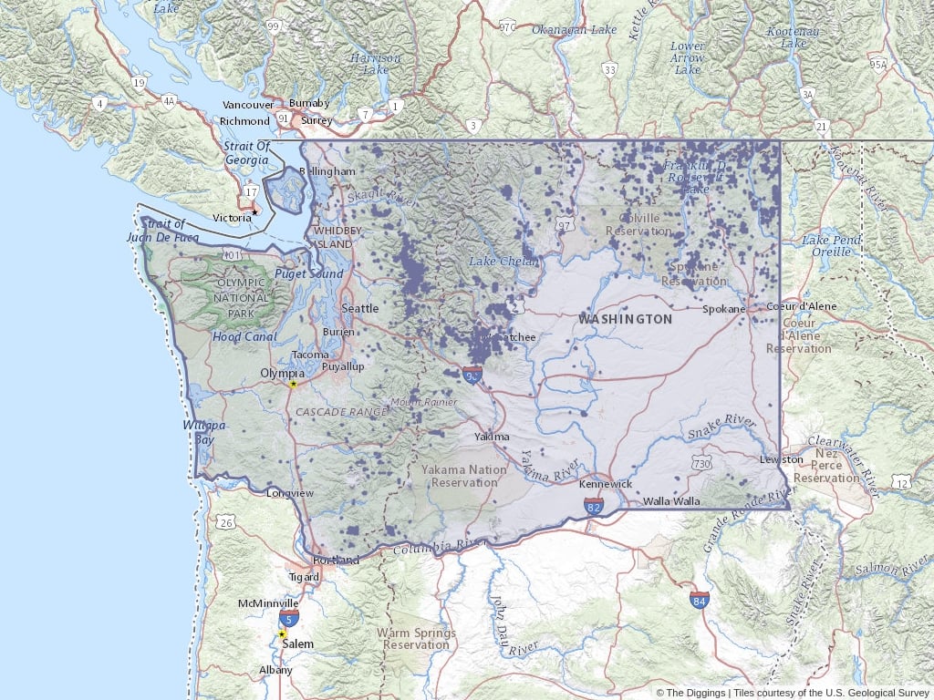
Washington Mine Locations
Click to open an interactive map.
© The Diggings™
Recently Updated Mining Claims
Most recently updated claims in Washington.
Mining Claims (BLM)
Washington has 58,272 mining claims on public land listed in The Diggings™. Of these claims, 4.91% are active while 95.09% are now closed. Ferry, Pend Oreille, and Okanogan are the most active counties in Washington.
Quick BLM Facts
- 58,272 records of mining claims on public land managed by the Bureau of Land Management.
- 2,862 records of active mining claims
- 55,410 records of closed mining claims
Washington Mining Image Gallery
-

Alamo Lode, 1896 Courtesy of Bureau of Land Management Washington -
Red Shirt Quartz Claim, 1889 Courtesy of Bureau of Land Management Washington -
Kangaroo No. 1 And 2 Lodes, 1905 Courtesy of Bureau of Land Management Washington -
Rebate And Relief Lides Mining Claims, 1896 Courtesy of Bureau of Land Management Washington -
Plug Hot Lode, 1998 Courtesy of Bureau of Land Management Washington -
Sherwood No 2 Placer Claim, 1890 Courtesy of Bureau of Land Management Washington


Washington Trends Overview
January 2021 vs. January 2020
January 2021
January 2020
Net
Change
Opened Claims
0
4
4
100%
Opened Acres
0
82
82.63
100%
Transfered Claims
0
1
1
100%
Transfered Acres
0
20
20.65
100%
Closed Claims
1
1
Closed Acres
20
20
0.65
3.29%
Located Claims
0
4
4
100%
Located Acres
0
82
82.63
100%
Rejected Claims
0
1
1
100%
Rejected Acres
0
20
20
100%
Mining Trends
Historic Mining Records (USGS)
Washington has 4,995 identified mines listed in The Diggings™. The most commonly listed primary commodities in Washington mines are Gold , Silver , and Copper . At the time these mines were surveyed, 1,737 mines in Washington were observed to have ore mineralization in an outcrop, shallow pit, or isolated drill hole—known as an occurance mine.1 Washington has 1,591 prospect mines.2 1,625 mines were in production at the time the data was entered into USGS records. Okanogan, Stevens, and Chelan are the counties with the most mines.
Quick USGS Facts
- 4,995 records of mining mines in Washington.
- 1,591 records of prospects
- 1,737 records of mineral occurrences of observable ore mineralization.
- 42 records of mining plants
- 1,625 records of mineral producers
1 Grade, tonnage, and extent of mineralization for such mines are unspecified.
2 Such mines have some degree of development such as surface trenching, adits, shafts, drill holes, geophysics, geochemistry, or geological mapping to estimate grade and tonnage.
Popular Public Lands & Regions
in Washington
Land TypeTotal ClaimsActive ClaimsClosed ClaimsActive AcresTotal MinesProspectsOccurrencesPlantsProducers
Colville National Forest
National Forests
10,620
803
9,817
16,515.02
386
174
130
3
79
Okanogan National Forest
National Forests
8,072
352
7,720
7,268.19
219
72
54
2
91
Gifford Pinchot National Forest
National Forests
3,571
301
3,270
6,546.56
98
31
35
0
32
Wenatchee National Forest
National Forests
15,220
289
14,931
6,104.22
476
192
152
5
127
Mt. Baker National Forest
National Forests
4,867
226
4,641
5,021.58
523
206
201
2
114
Top Mining Districts
in Washington
StateTotal ClaimsActive ClaimsClosed ClaimsActive AcresTotal MinesProspectsOccurrencesPlantsProducers
Metaline Mining District
Washington
564
563
1
11,592.45
181
89
41
1
50
Myers Creek Mining District
Washington
1,006
371
635
7,661.54
75
11
18
1
45
Blecher Mining District
Washington
377
226
151
4,270.83
20
4
11
0
5
Swauk Creek Mining District
Washington
215
169
46
3,205.86
61
17
15
0
29
Washougal Mining District
Washington
143
134
9
2,937.08
30
7
10
0
13
Top Owners
in Washington
CityStateCategoryInterest RelationshipTotal ClaimsActive ClaimsClosed ClaimsActive Acres
Adamera Minerals LLC
Vancouver
British Columbia
Corporation
Claimant
836
744
92
14,793.75
Teck Cominco Washington Co.
Spokane
Washington
Corporation
Claimant
379
379
0
7,620.32
Black Jack Resources LLC
Washougal
Washington
Corporation
Claimant
206
116
90
2,396.56
Metaline Contact Mines
Pine River
Wisconsin
Corporation
Claimant
113
113
0
2,256.76
Minquest Ltd.
Reno
Nevada
Corporation
Claimant
73
73
0
1,508.18
Popular Towns, Cities, Etc.
in Washington
CountyStateTotal ClaimsActive ClaimsClosed ClaimsActive AcresTotal MinesProspectsOccurrencesPlantsProducers
Curlew
Ferry
Washington
6,780
710
6,070
13,916.61
189
27
77
2
83
Malo
Ferry
Washington
6,723
641
6,082
12,491.07
191
28
77
2
84
Ione
Pend Oreille
Washington
4,076
568
3,508
11,673.76
325
140
96
6
83
Metaline
Pend Oreille
Washington
3,858
568
3,290
11,673.76
312
142
86
5
79
Metaline Falls
Pend Oreille
Washington
3,773
568
3,205
11,673.76
307
141
84
5
77
Mining Claim News From The Diggings™
Learn more about the Bureau of Land Management, Public Land Survey System, and mining claims.
-

Understanding Claim Ownership
We receive lots of emails from people who find their name or a relative’s name on our site and want to know if this means they have some right to the land listed under that name.
-
Understanding BLM Administrative Areas
Whether it is filing a mine or researching one, the administering BLM office is going to be the definitive source.
-
Understanding Location Data
Mine handled by the Bureau of Land Management are not mapped by latitude and longitude, instead, these mines harken back to the Public Land Survey System.
-
Understanding Townships
A “township” can refer to two different things. Both are part of the PLSS measurement system but have different uses.